
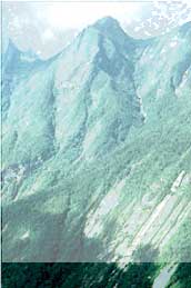
Armed with scientific data, the Peruvian government worked hard and fast to create the Parque Nacional Cordillera Azul. Barely eight months after the scientific team left the field, Peru's President Valentín Panagua signed the decree declaring a 5,225-square-mile national park.  Establishing the park was only the first step to ensuring the survival of these unique natural communities. Now many collaborators are working with the Peruvian government to ensure full protection of the Park. CIMA, a Peruvian conservation organization, is part of the team of nongovernmental organizations implementing the Park in partnership with the government agency INRENA and with technical support from The Field Museum. Lucho Benites became the first Park Chief in July 2002, and park guards have assumed their posts along the western border of the Park (the one most vulnerable to incursions). Establishing the park was only the first step to ensuring the survival of these unique natural communities. Now many collaborators are working with the Peruvian government to ensure full protection of the Park. CIMA, a Peruvian conservation organization, is part of the team of nongovernmental organizations implementing the Park in partnership with the government agency INRENA and with technical support from The Field Museum. Lucho Benites became the first Park Chief in July 2002, and park guards have assumed their posts along the western border of the Park (the one most vulnerable to incursions).The neighboring residents are thoroughly engaged in implementing the Park - from delineating the borders to constructing and installing park signs and eventually to patrolling the limits and censusing the wildlife. INRENA with the support of the Park Team is developing a comprehensive management plan, the Plan Maestro, for Parque Nacional Cordillera Azul. Involvement of neighboring communities - critical to the long-term survival of the Park - is at the center of the dynamic, collaborative programs within the Park and its buffer zone in the Huallaga and Ucayali valleys. |
||
 |
 |
Park Story | Park Map | Tools | Image Gallery | Science in Action Home | Calumet BioBlitz Home |
||
© 2002 The Field Museum, All Rights Reserved 1400 S. Lake Shore Dr, Chicago, IL 60605-2496 312.922.9410 |
|